
ViewRanger, the outdoor discovery app, today launches Skyline, a stunning new way to explore the outdoors with augmented reality. This revolutionary technology brings maps to life by using the camera on your phone or tablet to annotate and interact with the landscape around you. Skyline is a free update in the latest version of the ViewRanger app, and is available now in the Apple App Store and coming soon on Google Play.
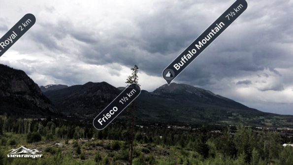
Skyline identifies peaks, places, passes, and lakes up to 20 miles away through your camera, then overlays their names into the landscape. When navigating a pre-planned route, waypoints and directional arrows also appear in front of you, offering an accurate and enhanced navigational experience.
“Skyline effectively tells you what you’re looking at and shows you which way to travel, changing how you view and interact with the landscape,” said Craig Wareham, ViewRanger co-founder and CEO. “When we started ViewRanger, our vision was always to place map information directly into the landscape around the user. Now, ViewRanger Skyline makes that a reality and it’s ready for anyone to use on their next walk, hike, bike, or visit to a park.”
To use Skyline, simply download and launch the latest ViewRanger update, tap the Skyline button on the map screen, and pan the landscape in the modified camera view to transform your next outdoor adventure.
IT WORKS OFFLINE
Like the ViewRanger app, Skyline works without phone or data signals by using the GPS chip and sensors built into mobile devices to understand your location and position. It also uses offline maps that you download and save to your device before leaving home.
EXPLORE THE WORLD
Skyline works across 80% of the globe, essentially everywhere except the northern and southern polar regions. “We’ve been developing Skyline for a number of years and it’s a great feeling to finally deliver it. We’ve had a very positive reaction from early users in countries such as the USA, Japan, Australia, France, Italy, and the United Kingdom; and now we’re excited to hear what outdoor enthusiasts around the world think of it,” said Mike Brocklehurst, CTO and co-founder of ViewRanger.
DOWNLOAD THE APP
Skyline for Apple iPhone and Apple iPad is available as an update in the free ViewRanger app on the Apple App Store. Coming soon to the ViewRanger app on Google Play. Learn more at: www.viewranger.com/skyline
ABOUT VIEWRANGER
ViewRanger is the outdoor discovery app, helping active people worldwide to plan, navigate, record and share their adventures. ViewRanger contains hundreds of thousands of downloadable route guides, provides free maps for the whole world, delivers powerful GPS navigation features and allows users to record tracks and view live trip stats. The app also works offline without phone or data signals anywhere in the world.
More than 600 partners — such as national parks, official tourism agencies, and travel writers — use the app to publish their route content to ViewRanger’s global audience. ViewRanger is also used and trusted by more than 200 search and rescue teams across Europe, US, and Canada.
In September 2016, ViewRanger was selected by Apple as the first hiking app to use the new built-in GPS on Apple Watch Series 2, and was invited on stage at Apple’s keynote event in San Fransisco to demo the app to a live global audience of millions of people.
Learn more at www.viewranger.com